Sunday, May 8, 2011

Mapping Skills


  1. What is it about the pressure system stalled over Australia that relates to the weather over the next 4 days?
A high pressure system lingers over the South-East of Australia. 

2. What is the air pressure in each of the next 4 days for each of the capital cities? How does this correspond with the predicted weather for these cities?

SYDNEY - Thursday: 1020ha, Friday: 1020ha, Saturday: 1020ha, Sunday: 1016ha
These high pressure systems are shown in the constant temperatures occurring in Sydney over the next 4 days. 

ADELAIDE - Thursday: 1029ha, Friday: 1026ha, Saturday: 1020ha, Sunday: 1020ha
The constant temperatures are the result of this steady high pressure system. 

MELBOURNE - Thursday: 1022ha, Friday: 1025ha, Saturday: 1016ha, Sunday: 1020
The steady system shows the steady temperature and cloud cover. 

BRISBANE - Thursday: 1016ha, Friday: 1016, Saturday: 1016ha, Sunday: 1017ha
High pressure system is steady over those days and the temperature also remains similar. 

PERTH - Thursday: 1016ha, Friday: 1016ha, Saturday: 1016ha, Sunday: 1016ha
In Perth it remains mostly sunny on that weekend. 

DARWIN - Thursday: 1014ha, Friday: 1014ha, Saturday: 1014ha, Sunday: 1014ha
The temperature continues to remain the same in Darwin - mostly sunny with low-30's. 

HOBART - Thursday: 1024ha, Friday: 1024ha, Saturday: 1016ha, Sunday: 1016ha
Hobart remains to have various showers due to the minimal change in the pressure system. 


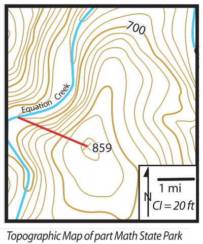
1. What is the contour interval (sometimes abbreviated CI)? Convert to metric.
The contour interval is 6.1 metres. 

2. What is the scale of the map? Convert it into the metric system.
1cm = 1.6km

3. What is the gradient of the line? Calculate in metric system.
48.8 divided by 3200 = 0.015km or 15metres

Sunday, May 1, 2011

Additional Questions

1. What is the distance and local relief between the centre of the pine plantation and the factory?
Distance of 5km and a local relief of 150 metres.

2. Give the Grid Reference for the Coal Mines as well as the local relief and distance between them.
GR829472 and GR894475, the distance is 3.25km and the local relief is 210 metres.

3. Give the Grid Reference for the intersection of the walking track and sealed road.
GR844440

4. What is the air pressure at Sydney and Perth?
1019ha at Sydney and 1012 at Perth

5. What is the wind speed  and direction at Rockhampton?
14-23km/h going east.

6. What is the Latitude and Longitude at Melbourne?
36'S and 144'E

7. What is the Latitude and Longitude where it is raining?
16'S and 128'E

8. What is located in the SW just off the map?
An extreme low pressure system. 

Athens in Five Images

1. Restoration - Athens experiences much acid rain and as such buildings are often vulnerable to wearing and erosion. One such building is the Parthenon which is one of the biggest tourist attractions in the world and so due to acid rain it needs to be restored into a quality condition and some of the marble bricks need to be replaced.

2. Deforestation - Due to the ever increasing population in Athens, they have needed to expand their territories outwards by huge amount. During expansion of the city they have come across various obstacles; forests and trees being one of them and so deforestation has occurred in order to continue Athens' growth.


3. Reservoirs - Another demand to the increasing population in Athens was the need for fresh, clean water. Lake Marathon is an artificially constructed body of water that was created as an effect of the development of  the Marathon Dam. Interestingly, the material that the dam was made out of was the same as the materials used in the production of the Parthenon.

4. Athens Metro - Since its development in 2000, the Athens metro has reduced huge amounts of traffic on the streets and pollution from cars. The rapid transport system gets 1,150,000 riders a day. 

5. Athens Basin or Attica - Athens is built around four large mountains one of which has been declared a national park. The geomorphology of Athens has been deemed one of the most complicated in the world, (Geomorphology is the study of how certain land forms are created). Due to these landforms, a temperature inversion occurs, plus the addition of pollution has been causing air pollution problems for Athens.