- What is it about the pressure system stalled over Australia that relates to the weather over the next 4 days?
A high pressure system lingers over the South-East of Australia.
2. What is the air pressure in each of the next 4 days for each of the capital cities? How does this correspond with the predicted weather for these cities?
SYDNEY - Thursday: 1020ha, Friday: 1020ha, Saturday: 1020ha, Sunday: 1016ha
These high pressure systems are shown in the constant temperatures occurring in Sydney over the next 4 days.
ADELAIDE - Thursday: 1029ha, Friday: 1026ha, Saturday: 1020ha, Sunday: 1020ha
The constant temperatures are the result of this steady high pressure system.
MELBOURNE - Thursday: 1022ha, Friday: 1025ha, Saturday: 1016ha, Sunday: 1020
The steady system shows the steady temperature and cloud cover.
BRISBANE - Thursday: 1016ha, Friday: 1016, Saturday: 1016ha, Sunday: 1017ha
High pressure system is steady over those days and the temperature also remains similar.
PERTH - Thursday: 1016ha, Friday: 1016ha, Saturday: 1016ha, Sunday: 1016ha
In Perth it remains mostly sunny on that weekend.
DARWIN - Thursday: 1014ha, Friday: 1014ha, Saturday: 1014ha, Sunday: 1014ha
The temperature continues to remain the same in Darwin - mostly sunny with low-30's.
HOBART - Thursday: 1024ha, Friday: 1024ha, Saturday: 1016ha, Sunday: 1016ha
Hobart remains to have various showers due to the minimal change in the pressure system.
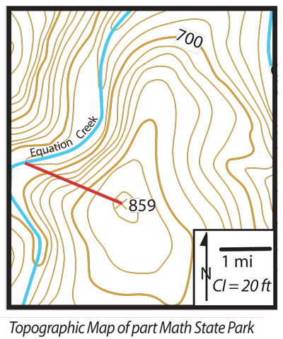
1. What is the contour interval (sometimes abbreviated CI)? Convert to metric.
The contour interval is 6.1 metres.
2. What is the scale of the map? Convert it into the metric system.
1cm = 1.6km
3. What is the gradient of the line? Calculate in metric system.
48.8 divided by 3200 = 0.015km or 15metres


No comments:
Post a Comment